Cairngorm Route and Profile
Maps and Profiles
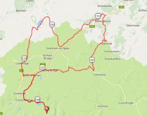
Cairngorm Mor
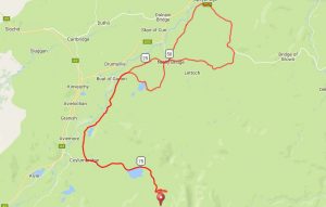
Cairngorm Beag
SEE THE MOR ROUTE ON RIDE WITH GPS – CLICK HERE
SEE THE BEAG ROUTE ON RIDE WITH GPS – CLICK HERE
Maps and Profiles
Cairngorm Mor
Cairngorm Beag
SEE THE MOR ROUTE ON RIDE WITH GPS – CLICK HERE
SEE THE BEAG ROUTE ON RIDE WITH GPS – CLICK HERE